 WeeklyTrail
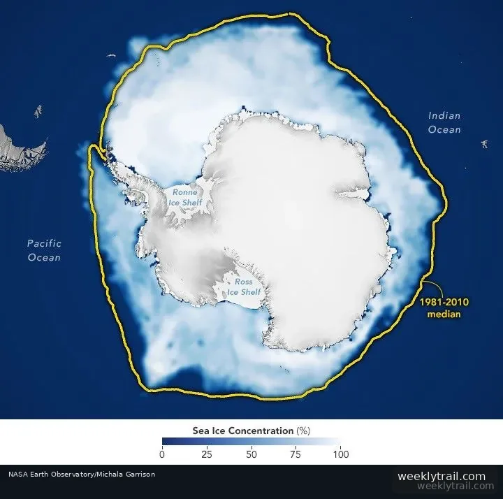
Antarctic sea ice likely reached its annual maximum extent on September 14, 2026, covering an estimated 17.59 million square kilometers (6.79 million square miles), according to NASA and the National Snow and Ice Data Center. NASA's Earth Observatory reported on October 12, 2026, that this was the third-lowest maximum in the satellite record.
Antarctic sea ice typically peaks in September, near the end of the Southern Hemisphere's winter, and retreats to a minimum in February. Because the continent is surrounded by ocean rather than land, the ice has more room to expand in winter, but it also reaches warmer latitudes and melts more in summer. Scientists measure extent as the area where ice concentration is at least 15 percent, a threshold commonly used with satellite data.
From 1979 until 2014, total Antarctic sea ice increased by about 1 percent per decade, though year-to-year variation made the significance uncertain. Record winter highs were observed from 2012 to 2014, but the climb ended in 2015 and significant decreases began in 2016. Both the record low minimum and record low maximum occurred in 2023. Scientists say it remains unclear whether the recent decline reflects a long-term change or a statistical fluctuation.

Start the conversation. A good question is half the story.